I just completed the 2016 Big Bend 30 K race. Words cannot begin to describe the meaning of this race for me. I’ve been asked to provide a complete narrative about the race, and I will attempt to do here for you what the race continues to do for me. Lengthy, but posting anyway.
I’ll post at the bottom with new stuff and a date stamp when I’ve added that info, so you don’t have to re-read the entire story again just to glean the new nuggets about how to enjoy Terlingua and far southwest Texas.

After a quick 9-hour drive from McKinney, you arrive in Terlingua….a place where time really doesn’t matter, unless you’re trying to get to Starlight’s opening doors for dinner at 5pm everyday. If you get to the front porch early, you can run a tab at the store next door with a variety of beer while you wait. Chances are really good there’ll be somebody playing Austin-ish folk music on the porch while you’re there. Every year I’ve been here, the music has been hands-down awesome.
Plus you get to enjoy the view! I’ll never grow tired of sitting and looking at the Chisos Mountains while the sun sets…..maybe you’ve seen a picture.
The cabin I rented, is small, quaint, cheap, and what I need: a little bit of electricity, a working shower/toilet, a fire pit/place, and a comfortable bed. Water out here is SCARCE. Part of the trip is you have to plan your own logistics: food, water, lodging, race prep, post-race plans….better for you to have something and not need it than the reverse. There are lots of options for cabin rental, airbnb.com, bigbendholidayhotel.com, La Posado Milagro hotel….camping, trailers, casitas….depends on your budget and the number of paying contributing people who might be staying with you. If you rent in the ghost town of Terlingua, you’re likely renting Adobe mining huts made as early as the 1880s.

The first year out here, several of us MRC and I rented a place north of Study Butte (just east of Terlingua) that was perfect. Maybe you’ve seen the pictures. The next year, a few of us from MRC and Mindy I rented a place on the Rio Grande. To hear more about these places please ask. For any of the above, bring your own firewood and booze.
It is very quiet out here….and at night the stars are too numerous to count! You can see the Milky Way, satellites…and tens of thousands of (if not more) stars.
For the race, the last two years have been at the Big Bend State Park, west of Terlingua, and closer to Lajitas (pronounced like “fajitas”). Choose from the 50 miler (2000′ of elevation gain), the 30k (1000′ of elevation gain), and the 10k (why bother?).
When you come out for race weekend, runners can identify other runners very easily. Most are from Austin and San Antonio, but as with any race, you’re sure to meet people you’ll see year after year. You’ll sit on the front porch trading race stories, kids, whatever, year after year.

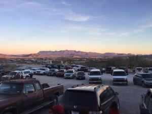
Then race day…you’ll have a commute of anywhere from hours to 15 minutes, depending on where you stay relative to the Big Bend State Park Headquarters, which is the start/finish. Like any race, if you train, you’ll do okay. But you can’t fully prepare yourself for the rocks, ruts, rock trail, dirt trail, soft deep sand, the elevation changes, and the temperature swings. I’ll post pictures as comments so you can see. Start temp is as low as the mid-30s, and warms up to the mid-60s at peak. Wear layers, and be prepared to shed them as you go. You WILL NEED A BIGGER water bottle/run belt than what you would use for a normal street race. I use a NATHAN 16oz bottle-belt combo. You are running in basically a desert, so keeping hydrated is very important, lest anybody sees totem poles (true story, to protect the innocent, I won’t reveal names). For the 30k, distances between aid stations varies from ~4 miles to ~6 miles. Aid stations are well stocked with water, bananas, oranges, cookies, pretzels, something passing for Gatorade, and are staffed by HAM radio people that LOOK for your bib number to make sure YOU aren’t horizontal somewhere on the course. Don’t forget to thank the aid station people!
First year I stopped at mile 25-ish aid station as I was ravenously hungry….”oh they have peas!” I scooped and ate an entire handful in one big quick bite. They were wasabi peas. Imagine and paint the next moments as a mental picture!
Finally, the race…..

It is serene. It is quiet. It is still. It is the person between your ears you need to deal with. The views are spectacular…..mountain vistas with the rising sun….running into and out of the shadows of mountains, up steep slopes, dealing with ruts, rocks, boulders, damn it’s still cold, loose dirt, down steep slopes, which rut to run in, arroyos, goddamn everything has at least 1″ thorns, the rocks are sharp, I’ve had a lot of water but don’t have to pee, washouts, am I even on the correct trail, will my garmin battery keep up, I really have to pee NOW, shit I’m running out of water, I didn’t get enough sleep last night, there’s a photographer up ahead I better start running, come on Garmin I’m almost there, boy I need to quit drinking (just kidding), and finally you dealing with YOU and all the rust that only running can wire-brush off your soul…

It was never stated more obviously than this, when at mile ~16 (?) a guy behind me slipped and fell down an embankment…..picking himself up he said you’re never really a trail runner until you fall. He picked himself up, and kept going. The comment was really striking, because earlier at mile 15.23 (I looked), I tried changing ruts from left to right, and my left foot hit a rock about the size of a large pumpkin while the right foot was up: down I went. I didn’t panic as it happened, either, just “change ruts to the right….now I’m falling….look at

those thorns, elbow up…impact.” I laid there for a minute looking around to see if anybody noticed (no one did), and I picked myself up and kept going!


Running low on water! Aid station 1


That’s the story of life! You might stumble and fall….but don’t panic. Pick yourself up and keep going. I’ll be back next year….and if any of you see a Brian-shaped crater at mile 15.23, take a picture of it!
January 23rd, 2016:
First, I strongly recommend leaving McKinney, if driving, no later than 5-5:30am. This puts you into Terlingua around 3-4pm at the latest if you haven’t dilly-dallied on the drive over, and you’ve got daylight to see you to your lodging. If you fly to Midland or maybe El Paso and rent a car to Terlingua, the more daylight you give yourself when you arrive at Terlingua will help.
When I said “time doesn’t matter in Terlingua” except if you’re trying to eat at Starlight restaurant and bar when it opens at 5pm everyday…that does NOT mean you have to eat at 5pm. Last several visits I’ve sat on the front porch and watched the sun set on the Chisos mountains, enjoyed the beers I’ve bought from my tab at the Terlingua Trading Post, taking pictures of the colors of the Chisos mountains every few minutes. The sun sets around 6:10-20 ish pm, so instead of going inside Starlight and eating, sit out and relax, while you sip your beer.
For breakfast if you don’t make/bring any in your rental, La Posado Milagro runs a coffee shop to the right of Starlight by 20 yards ish. Day after the race a guy ordered a Belgian waffle complete with strawberries. They make great coffee, and a breakfast burrito hits the spot. As of January 2016, Starbucks hasn’t shown up.
Because after all in Terlingua, time doesn’t matter, or at least not until race day morning.
As far as the cell coverage goes, at least as of my visit last week, after you head south from Alpine to Study Butte on Texas 118, you will lose coverage 10 miles-out of town. Siri/Waze tried to tell me to head to Marathon from Alpine, but continue to head south, and 2-3 hours later you’ll get to Study Butte. If you choose to do so, you can get groceries in Alpine or in Study Butte. Once you get to Study Butte and Terlingua, you’ll have cell coverage…again, as of this last week. My carrier is AT&T.
But roads west of Lajitas heading to Presidio (if you decide to explore) may have spotty coverage. If you drive to Big Bend National park, you’ve got a 20-30 minute drive to the gate, a $25 park pass fee (good for the duration of your stay, regardless if you stay off the National Park), and then another 45 minutes to the lower visitor’s center. If you want to go to the visitor’s center up in the heart of the Chisos mountains, you’ve got another hour-ish drive….in part because the speed limit on the Park is 45-55 mph, and you’ll most likely be stuck behind some 50′ motor coach towing a jeep with a motorcycle and a kayak on the roof….don’t speed. Cell coverage in the park is also spotty. Around the Chisos visitor’s center, you’ll have wifi.
The Chisos mountains visitor’s center is quite nice: lodgings, a restaurant, bar, nice gift shop, outdoor eating, and scenic vistas. There are several hours’ duration hiking trails to even more spectacular vistas.
There are hot springs down on the Rio Grande deep in the park…at 45-55 mph, depending on the zone. Remember, time doesn’t matter.
